GEOTECHNICAL ENGINEERING
IRVING
HomeSlopes & WallsSlope stability analysis

Slope Stability Analysis in Irving, TX

Site investigations you can build on.

LEARN MORE

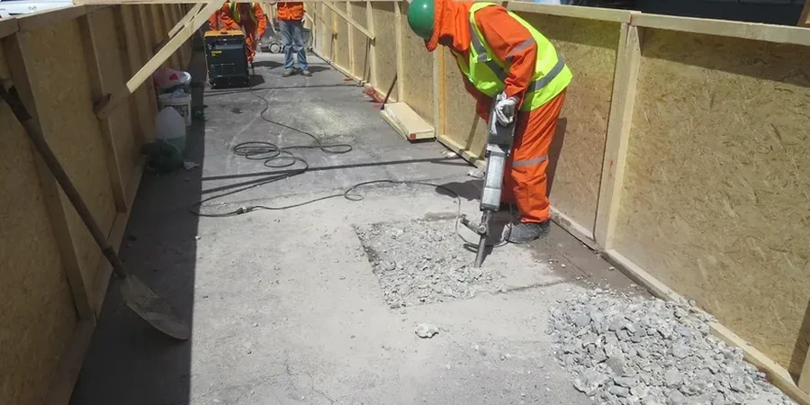
The Eagle Ford Shale formation that underlies much of Irving creates a specific set of problems for any cut deeper than about eight feet. When this clay-rich rock weathers near the surface it turns into a highly plastic soil that swells after rain and shrinks during the long dry spells common to North Texas. We run our slope stability analysis here with that exact material behavior in mind. A proper triaxial test on an undisturbed sample from the face of the excavation tells us more than a standard bearing capacity check ever could. The city’s stormwater drainage corridors along the Trinity River tributaries add another layer of complexity—saturation cycles that degrade the apparent cohesion over just a few seasons. We’ve seen this across projects near Campion Trail and the Las Colinas Urban Center.

A stable slope in Irving isn’t just about the angle—it’s about managing the suction loss in the upper five feet of weathered Eagle Ford clay after a three-day storm.

Our service areas

Process and scope

Conditions change fast between the hard limestone benches west of Loop 12 and the softer alluvial deposits closer to the Elm Fork. Near the old Texas Stadium site we typically deal with stiff fissured clay where deep tension cracks propagate fast after excavation—that’s a classic setup for a delayed rotational failure. On the east side, where residential development pushes into gentle slopes, the weathered shale transitions into a material that erodes internally during heavy storms. Those sites often need a retaining-walls design integrated into the stability model, not as an afterthought but as the primary stabilization element. We run back-analysis on failed slopes in the area to calibrate our parameters, combining lab-derived friction angles from grain-size distributions with field observations of groundwater perched within the weathered zone.
Slope Stability Analysis in Irving, TX
Technical reference — Irving

Site-specific factors

Our field crew uses a truck-mounted CME-55 drill rig to push through the weathered shale and set the slope inclinometer casings that feed the stability model. The machine stands about 28 feet tall with the mast up and runs a hollow-stem auger that keeps the borehole open in the fractured upper rock. Without that setup you lose the hole before the casing goes in. The real risk we address in Irving is the progressive loss of suction in the surficial clay layer. A slope that stands at 1.2:1 in August can fail at 1.8:1 in March after steady rain saturates the top few feet. We model that transient condition explicitly rather than assuming a single worst-case water table. For cuts deeper than 15 feet near the SH-114 corridor we also check the pseudo-static case because the soil amplification on the shale bedrock can surprise you—the site class changes fast here.

Need a geotechnical assessment?

Reply within 24h.

Email: [email protected]

Reference standards

ASCE 7-22 (Minimum Design Loads for Buildings and Other Structures), IBC 2021 (International Building Code, Chapter 18), ASTM D1586 (Standard Penetration Test), ASTM D2487 (Unified Soil Classification System), TxDOT Geotechnical Manual (2022)

Technical parameters

ParameterTypical value
Analysis methodLimit equilibrium (LEM) per ASCE 7-22
Failure modes checkedRotational, translational, compound, wedge
Typical slope height8 to 35 ft for commercial cuts
Key soil unitWeathered Eagle Ford Shale (CH/CL)
Pore pressure modelSteady-state seepage with perched water
Factor of safety target1.5 static, 1.1 pseudo-static (per IBC)
Back-analysisCalibrated with local failure case histories

Common questions

How much does a slope stability analysis cost for a project in Irving?

A typical commercial slope stability study in Irving runs between US$1,370 for a straightforward single-section analysis of a small cut under 12 feet, up to US$4,520 for a multi-section model with inclinometer installation, lab triaxial testing, and pseudo-static seismic checks per IBC Chapter 18.

What triggers a slope failure in the Eagle Ford Shale around here?

The main trigger is loss of matric suction in the weathered upper zone. After two or three days of steady rain, the negative pore pressures that hold the clay together dissipate, and the apparent cohesion drops sharply. Cracks that opened during the previous dry spell then fill with water, adding a driving head at the back of the failure mass.

Do you need a drilling permit on private property in Irving?

No separate drilling permit is required from the city for geotechnical borings on private commercial lots. If we need to set inclinometer casings within a public right-of-way or a TxDOT easement, we pull a right-of-entry permit which typically takes three to five business days.

How long does the analysis take from start to finish?

Field drilling and inclinometer installation takes one day. Lab triaxial testing on the recovered samples runs five to seven working days. The LEM modeling and report drafting take another three days after lab data comes in. Total turnaround is about two weeks from mobilization to final report delivery.

Location and service area

We serve projects in Irving and surrounding areas.

View larger map